My first introduction to the Carretera Austral was in 1998, when I led a group of photographers down a section of the road from Chaitén to Coyhaique. I had to wait 16 years to drive the remaining sections of the highway - but it was worth the wait!
 Pumalín
The Carretera Austral, Chile’s iconic highway linking remote communities, stretches 1,247km from Puerto Montt to the northern shores of lake O’Higgins where indomitable mountains and frozen ice fields, for the moment, defeat this feat of engineering.
Opening up virgin territory is always controversial and the history of this road is no exception. The whole Aysen region was a pawn in territory disputes during much of the 19th century. Settlement (‘colonisation’) and deforestation were actively encouraged, leading directly to the scenes of desolation which will still be visible for hundreds of years to come. Politics again led the way in 1976 when the project began under General Pinochet - it is no coincidence that Chile and Argentina were at that time still smarting from one of their many border disputes, and the new road was one way that Chileans could travel through their country without having to enter Argentina.
 Hornopirén ferry
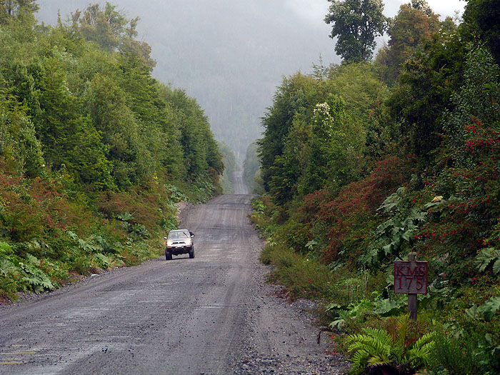
The Carretera Austral officially starts in Puerto Montt, a major port and also jumping-off point for the mystical (and often misty) island of Chiloé. Heading south along the edge of a Pacific fjord, a paved road leads after about an hour to the first (of four) ferry crossing, at La Arena. This is a short (45’) journey which runs regularly during the day, but anyone with a reservation on the next ferry (Hornopirén), needs to start early. During the next 55km section one starts to feel the vegetation as the road (dirt, but being asphalted) cuts through thick forests and across tumbling streams past remote homesteads. If you have started early enough there may even be time to stop at one of the hot springs, whose steam rises from clear and fresh river water through the branches of the forest canopy above.
Every day at 10am the longest ferry journey of the route departs from the jetty at Hornopirén, heading south along the tranquil waters of another Pacific fjord before finally docking at Leptepu 3½ hours later. A mad dash along 10km of gravel road to the next ferry ensues, although as the schedule in synchronised a place is guaranteed for everyone. 40 minutes’ ride later and the bicycles, lorries and cars finally arrive at Caleta Gonzalo, the northernmost gateway to Pumalín national park.
For those wanting to experience the effect of 7,000mm of rainfall per year, and lovers of the resulting exuberant vegetation, a night or two at the simple but cosy wooden park cabins are well-spent. The many trails are well marked and suitable for all levels of difficulty, provided always that you have sufficient protection from the relentless precipitation. It is 58km from Caleta Gonzalo to the ghost town of Chaitén (mainly gravel), and there are many signs of nature’s awesome power as you cross the Rio Blanco, which was the conduit for ash and meltwater when the Chaitén volcano erupted in May 2008, leading to the town’s abandonment for 5 years. New shoots of life are visible both in the town, and in the temperate rainforest swept by pyroclastic flows.
El Amarillo to Coyhaique
 Near Queulat
From Chaitén a smart tarmac road heads south-east and skirts the southern edge of Parque Pumalín, where the village of El Amarillo and community has been ‘prettified’ thanks to the encouragement of Douglas Tompkins’ conservation organisation. Valleys are broader, and possible side trips include hikes to glaciers, or fishing on pristine rivers and lakes. Just before La Junta a side road leads off to the east, through the lovely Palena and Futaleufú valleys (the latter is renowned as one of the world’s most exciting rivers for white-water rafting), to a border crossing with Trevelin and Esquel, in Argentina.
The Southern Highway continues south and touches the ocean again at Puyuhuapi, a quaint village on the shores of a peaceful fjord, one of whose claims to fame is a carpet factory founded by German immigrants in 1940. Just south of here is the Queulat national park, whose hanging glacier is a major attraction (a 3-4 hour hike). There are several lodging options in this area, from simple family guest houses to spa hotels. The road climbs a long escarpment and continues for a further 4-5 hours before joining the tarmac road that leads from the port of Puerto Aysén to the capital of the XI region, Coyhaique. The final stretch follows the Simpson river, whose lovely valley sides are lined with lupins - a stunning sight when they are flowering. Also visible along this section are the burnt stumps and bleached trunks of the forests that were felled indiscriminately, with government encouragement, for most of the last century.
Coyhaique is a busy little town, whose streets radiate out from a disorientating 5-sided square. There are plenty of small hotels, and a few fishing lodges in the surrounding countryside, and several possible side trips to quiet lakes or into peaceful woods. The main airport, with regular flights to the rest of Chile, is at Balmaceda, 56km south.
Balmaceda to Cochrane
 River Baker
From Balmaceda the Carretera Austral heads south-west, winding through the Cerro Castillo national park, overshadowed by the jagged peaks of the mountain that gives this pretty are of forested hillsides and wide alluvial valleys its name. Here too you will see nature’s force - the Hudson volcano erupted in 1971 and 1991 and signs of its fury still remain. Eventually the road, gravel again, emerges at the northern arm of enormous Lago General Carrera (shared between Chile and Argentina, and called Lago Buenos Aires in the latter), though valleys dotted with cypress trees (arrayanes). In February, when the trees flower and the lake is at its most cobalt blue, it is the most arresting sight.
Around Lago General Carrera the small settlements of Puerto Rio Tranquilo, Puerto Guadal, and Puerto Bertrand provide a few shops, the odd fuel pump, and a selection of small lodges and hotels. Activities include hikes to viewpoints over the Patagonian Ice Field (the northern section of which is first visible here), boat trips to the lake’s famous marble caves, riding, or even jet boat experiences. The lake drains to the Pacific via the mighty Baker river, which accompanies any journey south of here. The powerful current has punctuated both disputes (such as several schemes to harness the waters for hydroelectric schemes) and passions (the doughty first European pioneers here introduced brown and rainbow trout which have thrived in the gin-clear swirling waters and have grown to impressive sizes - the most trusty fly here is called the Chernobyl).
 Tortel
As the road heads yet further south you pass an arid section with gorges that cut through open country - and often provide the first sight of that emblematic camelid, the guanaco - the llama and alpaca’s distant cousin. Cochrane has the last bank, the last fuel station, and the last almacén, or general store, of any size on the Carretera Austral: you can buy anything from a picnic knife to an engine hoist.
For those retracing their steps to Balmaceda Tortel is the last stop on the highway. Founded by cypress exploitation companies around 1900 this small town made entirely from wood, clings precariously to the steep slopes around a calm Pacific fjord on the Baker estuary. There are no cars, no roads, only endless wooden walkways. Those who linger can explore the beach (only exposed at low tide), climb to the town antenna and viewpoint, or take a small boat to the enigmatic site of Isla de los Muertos where perhaps a hundred early pioneers perished.
The far south
 Near Villa O'Higgins
To continue south from this point one has to cross the final (free) ferry on the highway, from Puerto Yungay to Rio Bravo. From here, 100km of fine gravel road leads, past glacial lakes and up a long escarpment where condors often float, to the aptly named Lago Cisnes (Swan Lake), just to the north of Villa O’Higgins. This pioneering frontier town is a monument to corrugated iron, an outpost for Chile’s recently-formed ‘alpine’ division, and the end of the road until a new branch is built around the impassable southern ice field. O’Higgins is a fast-developing centre for walks, bike rides, and any other pioneering activity it can invent. Without retracing one’s steps the only onwards options are the Paso Mayer to Argentina (only passable in mid-winter when glacial meltwaters allow the intrepid to cross the Carrera river), or the windswept waters of Lago O’Higgins, on whose shores the 1,427km Carretera Austral finally ends. On certain days of the week, in high season (usually December to March) boats take travellers - and cyclists - south to the final Chilean outpost of Candelario Mancilla. From here the only way to proceed is to walk south to Lago del Desierto and hail a boat to link with the dirt road to El Chaltén in Argentina.
 Walking to Fitzroy
This is one of the most stunning walks I have ever taken, it is so easy to trip over a root because one’s attention is continually grabbed by what lies ahead: the soaring granite peaks of the Fitzroy massif clearly framed - on a sunny day - by the blue waters of the lake, its wooded slopes, and high above the creaking and complaining walls of yet another glacier.
Practical tips and advice
 Torres del Paine
To attempt the whole journey from Puerto Montt to Punta Arenas while doing justice to the diverse and stunning scenery that you will pass through will take 3 weeks to a month, and be subject to the vagaries of ferry timetables and hire car return fees. Shorter options include a northern circuit: starting or returning through Argentina and taking the side road via Futaleufú, allow at least a week, and you will add the contrasts of the sheep-farming ‘classic’ Patagonia with deep, arid canyons and killer bunnies.
A southern loop is possible starting and ending in Balmaceda, although some retracing is required - allow 4-8 days.
A Balmaceda/Punta Arenas option is also possible, leaving a hire car in Villa O’Higgins, crossing by land to El Chaltén in Argentina, visiting Calafate, and Puerto Natales (side trip to Torres del Paine recommended if you haven’t been there). 14 days required, and a prayer that your luggage will accompany you for most of the way.
The Magallanes ferry, which ran for years between Puerto Montt and Puerto Natales, offered a clever (and scenic, if the cabins were rather cramped) way to return a hire car to its original destination and avoid hefty drop-off fees. Navimag, the operating company, is having insurance issues at the time of writing and have suspended services to the public. Do contact me, or one of the team, for updates and advice on any of the above!
Comments
If we were to rent a car in Puerto Mont and go down to Balmaceda but not further south than Cerro Castillo and return to Puerto Mont via car how much time would you budget. If we did the same but one way how much time would you budget
Thanks
very helpful article. Hope you can offer some help. I am also planning to drive the CA like your previous commenter. Pick up car P. Montt and finish the drive around the Aysen area and looking at the options for return; a. Navimag via P Aysen, b. drop off the car and pay one way fee., c. cross the border into Argentina at either Chile Chico (or possibly Cochrane) and drive the No. 40 back up to P. Montt . I can't see if Navimag is taking vehicles (your 2014 article suggests they stopped taking cars as there was an insurance issue I wonder is this still the case?). I've been on their site and can only find reservations for foot passenger so have no idea if feasible/how much this would cost. Option B, trying to find out how much approx. a one way fee is and C. The fee for border crossing papers. I was also wondering if you could recommend a reputable hire company as I am reading conflicting advice regarding 4x4, height clearance car. I am expecting hefty damage waiver fees! Perhaps you could even quote for this?
Many thanks
One way fees aren't too bad between Balmaceda and Puerto Montt, but considerably more for Punta Arenas!
Do you know anything of the 2-stage vehicular ferry trip from Hornopiren to Caleta Gonzales at the north end of the Carretera Austral? All reference of it on the ferry company's (Taustral's) website seem to have gone, with only Puerto Montt to Chaiten seeming to be available.
Many thanks.
I think it was probably a Chile internet glitch, unless you were looking at one of the other companies, or dates when ferry times had not yet been loaded.
Kind Regards
The Hornopiren ferry operates all year so I think they just haven't loaded the March dates yet (I see it currently works up until 1 March only). The main issue at the moment is the large landslip at Villa Santa Lucia which cut the road south of Lago Yelcho (and tragically killed some local residents). The only way round is to take an extra ferry from Caleta Gonzalo to Puerto Raul Marin Balmaceda, which is linked to the Carretera Austral by a spur just south of Villa Santa Lucia. It is hoped that the road will be passable again by the end of February but it seems quite possible that it won't be. In your case, I would seriously consider crossing into Argentina from Pucón (a lovely drive), and going south to Esquel before crossing back into Chile at Futaleufú.
Best wishes, Ed
I'd like to do a road trip on the CA as well but am a little tight on time. I'm thinking of starting in Coyhaique and renting a car and hitting various sites all the way down to Puerto Natales and dropping off the car there instead of driving back to maximize time for exploring. I'm hearing drop off fees can be expensive AND I'm also having trouble finding a reputable car rental company that can also include camping gear in the rental. Any recommendations?
Also, do you know if rentals are better (or cheaper) from Coyhaique vs. Balmaceda?
Thank you!
Christina
Thank you for your kind comment! I don't know of any car hire company that includes camping gear, especially one with bases in both Balmaceda and Puerto Natales, so I think you should stick with either Hertz or Europcar. Both are Chilean franchises but pretty reliable. I am afraid the one-way fees are quite high, but then they do have to go a long way to drive your car back! I don't think there's any difference between Coyhaique and Balmadeca (which is really only the airport for Coyhaique).
With best wishes, Ed
First, thanks a lot for your article, very helpful !
I have one month and a half to spend in Patagonia and would like your advice ! I’m a sport person and am planning to do as many big hikes, kayak trips and outdoor things as possible. I saw the ruta de los parques and am thinking to go to less visited parks than Torres del Paine for example, and get a little bit lost :)
I have two options :
- Arrive at Puerto Montt by plane, rent a car and do the whole CA, but then I imagine the drop off fee at O’Higgins would be enormous
- Arriving at Balmaceda, doing a southern loop to O’Higgins then up to Puerto Montt.
- Then, leave the car and go down to El Chalten, then to Punta Arenas, trek there.
What would you recommend for the car ? Do you think my itinerary is a good idea ?
It is worth checking the one-way dropoff fees because they are usually not much more than the cost of the agency getting the car back to where is started, and can save you a lot of time. Looking at Hertz rates for 2019, they are about USD850 for Puerto Montt/Coyhaique (Balmaceda) and USD1,650 for Punta Arenas/Puerto Montt. Having said that, I think your second route idea could work quite well in the time you have.
The key car pickup/dropoff points for the Carretera Austral are: Puerto Montt, Coihaique (Balmaceda airport) and Punta Arenas (all in Chile). Both Hertz and Europcar have offices at all three. If you do a one-way rental there will be extra charges, but they only reflect the cost of getting the car back to where it started. Hertz will arrange a car pickup in Villa O'Higgins (I am not sure about Europcar). You could pick up a car in Bariloche, but would then need to drop it off in Argentina, so it would probably only work with Ushuaia, or if you are doing a complete loop.
My wife and i fly into Buenos Aires on Jan 1 and plan to drive the CA. There are so many options we dont know what to do. We plan to trek Cerro Castillo and fly fish along the way. Otherwise we just want hike and enjoy our trip. We fly out on the 30th so we have about 1 month total. Some options of come up with.
1) fly into coyhaique and drive up to pumalin and futaleufu and back to ruta 7 to Cochrane and up to chile chico and ferry back to Coyhaique to fly home
2) same thing but make a loop from Futalefu to el bolson and down to chico chile in argentina
3) Puerto montt to coyhaique
4) pucon or Bariloche to coyhaicue via esquel to futaleufu.
What makes the most sense? Any other ideas?
Thanks so much!
Cory
Thank you for your patience - I'm just back from Patagonia (fishing and riding near San Martin). I would suggest something like the following:
Spend a few days in BA, because it's a lovely city.
Fly to Bariloche and spend a few days there (probably not based in Bariloche itself, which has been visually damaged by uncontrolled development, but the surrounding area is beautiful).
Take the classic lake crossing to Chile (in either one or two days), and pick up a hire car.
Drive south, using the Hornopiren ferry, through Pumalin, Chaiten, Puyuhuapi, maybe Puerto Chacabuco (possible all day catamaran trip to the San Rafael glacier), and Coyhaique. Continue south at least as far as the Puerto Guadal area (further if you have time), stopping to a few days in Cerro Castillo for your trekking. Return and hand car back at Balmaceda airport (flights to Santiago).
It's generally advisable to hand a car back in the same country as you pick it up.
The scenery on Ruta 40 (i.e. on the Argentine side of the Andes) is not as varied as that of the Carretera Austral.
I hope that's helpful - have a wonderful time!